STRAWBERRY PEAK
Strawberry Peak as seen from the "Rim-of-the-World" Highway 18.
Type: Junction/Switched
Callsign: KMQ33
Location: Atop Strawberry Peak in the San Bernardino Mountains in San Bernardino County. Just 2 miles west of Rimforest and about 9 miles north of downtown San Bernardino.
LAT/LONG: 34.13.55 -117.14.04
Elevation: 6, 100 feet
Paths: Cline Springs, Keller Peak, San Bernardino, Corona, Padua Hills, Phelan and Table Mountain.
Notes: One of the most important sites in the Southern California microwave network. Used to "jump" microwaves from both the Los Angeles and San Bernardino Valleys over the mountains and toward the network in the eastern high desert. Site was constructed as part of the initial Long Lines microwave network in 1954 and built to be survivable and contained heavy concrete reinforced walls and emergency backup generators. Modified and strengthen horns provided protection from nuclear blasts and heavy snow loads. Site is well locked up and still owned by AT&T.
Click on pic for larger size
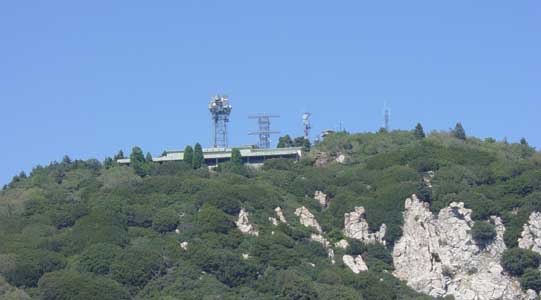
 View
from the bottom of the mountains in San Bernardino. Hard to see but it is
at the top of the center peak.
View
from the bottom of the mountains in San Bernardino. Hard to see but it is
at the top of the center peak.
 Facility
entrance. Site is still secured with cycloned wire fence and multiple
locks.
Facility
entrance. Site is still secured with cycloned wire fence and multiple
locks.
![]() Closer
view of garages used to store vehicles during the snowy winter months.
Note AT&T logo.
Closer
view of garages used to store vehicles during the snowy winter months.
Note AT&T logo.
 Top
roof of structure. Note emergency generator exhausts at center end of
roof.
Top
roof of structure. Note emergency generator exhausts at center end of
roof.
 Under
balcony type structure in the middle portion of the facility.
Under
balcony type structure in the middle portion of the facility.
 Microwave
tower looking toward the west. Horn pointed to Keller Peak.
Microwave
tower looking toward the west. Horn pointed to Keller Peak.
 Cable
entrance into building at base of tower.
Cable
entrance into building at base of tower.
 Close
up view of top of tower. Note modified horns and GEP antennas used in the
Echo-Foxtrot communications system.
Close
up view of top of tower. Note modified horns and GEP antennas used in the
Echo-Foxtrot communications system.
 Looking
toward the southeast. Horns at top pointed toward Phelan (top) and Table
Mountain (Bottom).
Looking
toward the southeast. Horns at top pointed toward Phelan (top) and Table
Mountain (Bottom).
 East
side of structure. Note unusual balcony type construction.
East
side of structure. Note unusual balcony type construction.
 AT&T
sign on entrance gate.
AT&T
sign on entrance gate.
 Base
of 155 foot microwave tower.
Base
of 155 foot microwave tower.
 Looking
southwest from Strawberry Peak toward the San Bernardino Valley 6000 feet below.
Looking
southwest from Strawberry Peak toward the San Bernardino Valley 6000 feet below.
Back to Microwave Sites: Southern California Microwave Sites Page 3
Back to Main page: Telephone Central Offices